Ecka Interchange on Future Highway Moved Toward Linglong Factory, Reconstruction of Zrenjaninac Possible Too – Preliminary Design of 1st Section of Vojvodina P Waiting for “Green Permit”
Source: eKapija
 Thursday, 01.12.2022.
 13:13
13:13
 Thursday, 01.12.2022.
 13:13
13:13
(Photo: Idejni projekat/screenshot)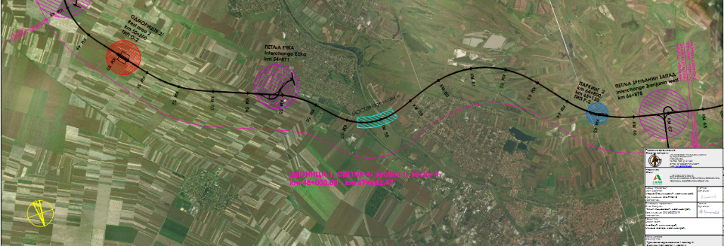

This is said in the request for determining the scope and the content of the environmental impact assessment study for the project of the construction of the 1st section of this highway, from Belgrade to Zrenjanin, which the PE Corridors of Serbia has submitted to the competent ministry.
The investors in the project are the PEs Roads of Serbia and Corridors of Serbia, and the preliminary design was prepared by AG Institut Novi Sad.
It seems that the new design would appease the Zrenjanin companies which have asked for the Ecka interchange to be moved several kilometers closer to Zrenjanin, compared to the design from the spatial plan.
The Zrenjanin Business Club (Zrepok) has explained the request with the needs of Linglong, but also the residents of Zrenjanin:
– The estimates are that, in the next several years, the number of heavy trucks from the industrial zones toward the Ecka interchange and vice versa will amount to around 1,000 a day, in both directions. A large number of those trucks would have to travel three kilometers toward the south to the Ecka interchange, and then go back and travel to Novi Sad, that is, the EU states. This especially pertains to the transport of goods from the production facilities of Linglong, whose purchasers are mostly located in countries which are big car manufacturers in western and northern Europe. Our proposition would reduce the traffic jams, the transport costs and the pollution. We would also get a much shorter and simpler road to Novi Sad, which would also serve the residents of the southern part of Zrenjanin – Zrepok said.
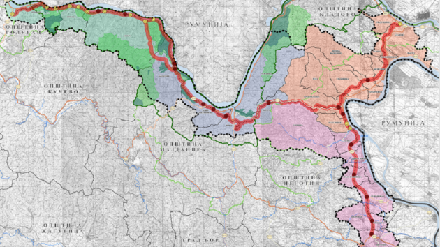
According to the request that the PE Corridors of Serbia has submitted to the ministry, the project of the highway of a total length of 110 kilometers entails the construction of a full highway profile which will have an impact on increasing the regional importance of the south Banat area, because, thanks to its position, it will improve the traffic service of the local self-governments covered by the project, but also the wider area covered by the “Banat Main Road”.
The request presents, in detail, the route of the highway section Belgrade-Zrenjanin, from km 0+000.00 to km 67+662.47.
The beginning of the route is planned at the Ovca interchange, on a part of the so-called Northern Main Road Tangent (SMT). The route further crosses the railway, goes toward the northeast and passes the area covered by agricultural land, then crosses the Tamis river in the spot where a bridge is planned.
The route further continues northward, where the Glogonj/Jabuka and Kovacica interchanges are planned.
– In this part, the position of the route would be conditioned on the position of the built irrigation system and the planned wind farms. All the restrictions in that part are overcome through the provided design – the project says.
After the planned Kovacica interchange, the route turns slightly toward the northwest and right before the Outstanding Natural Landscape “Potamisje”, it further goes northward, where a bridge on the Tamis is planned, crosses the railway and further continues northward, where the Orlovat interchange is planned.
Further, after the interchange, the route turns toward the northwest, toward Ecka, where the Ecka interchange is planned near the tire factory under construction (Linglong). The route in this part is planned south from Zrenjanin.
Then, continuing westward, the route crosses the Begej river and continues toward the planned Zrenjanin Zapad interchange. This interchange is at the same time the end of Belgrade-Zrenjanin Section 1 (along with the connection to the bypass route north from Zrenjanin).
The preliminary design splits Section 1 into 4 sectors, presents them in more detail and introduces certain changes compared to the spatial plan:
Sector 1 – Ovca – Glogonj/Jabuka
It is planned up to km 11+500.00, in the length of 11.5 km. The beginning of the traffic route is planned in the proximity of the existing traffic route SMT, following the deleveled Ovca intersection. The route then goes in the south-north direction, crossing the existing network of amelioration canals, which are mostly set up along the east-west direction, as well as numerous farm roads. On most of them, bridge structures within the highway profile are planned. Deleveled crossings – overpasses are planned across the highway, at the crossings with the more important local traffic routes. The project envisages a trumpet-type deleveled intersection (Glogonj, at km 10+946.60), which enables traffic communication of the existing settlements with said highway route. Within the deleveled intersection, a “lateral” toll booth is planned. At km 7+450.000, a “frontal” toll booth is planned.
Sector 2 – Glogonj/Jabuka – Kovacica
The beginning of Sector 2 (in the length of 19.7 km) is planned after the deleveled intersection Opovo, at km 11+500. The route then goes down the south-north direction, crossing the existing network of amelioration canals, which are mostly set up along the east-west direction, as well as numerous farm roads. On most of them, bridge structures within the highway profile are planned. On most of them, bridge structures within the highway profile are planned. Overpasses are planned across the highway, at the crossings with the more important local traffic routes. On Sector 2, the plan is to also build the trumpet-type deleveled intersection “Kovacica” (at km 29+500). Within the deleveled intersections, a “lateral” toll booth is planned, and a rest spot is also planned at km 17+700. On this section, the route of the highway goes across the planes, west of the settlements Crepaja and Debeljaca, all the way to the urban area of Kovacica. The highway route crosses the roads: Crepaja-state road 131, Crepaja-Sefrekin and Debeljaca-Opovo.
Sector 3 – Kovacica – Orlovat
It begins after the deleveled intersection Kovacica at km 31+200.00 and ends after the deleveled intersection Orlovat at km 48+000,00. The total length amounts to 16.80 km. On roughly the first 4 kilometers, between Kovacica and Idvor, the planned axis of Sector 3 is to the right of the existing IIA-grade road no. 129 (Kac-Sajkas-Titel-Perlez-Secanj-state border with Romania). Further on, the route passes in a short length on the embankment across the Outstanding Natural Landscape “Potamisje”, and in a greater length, on the structure whose length is close to 2,851 meters. At km ~42+527, the highway route crosses the regional railway no. 6, across which an overpass is planned. Not far from Orlovat, the eponymous deleveled intersection is planned, securing a connection of the IIA-grade state road no. 130 with the new highway. Right after the deleveled intersection Orlovat, at km 48+000.00, the end of Sector 3 is planned. On this section, several bridge structures are planned.
Read more:
Sector 4 – Orlovat – Ecka
According to the previous design, Sector 4 (Orlovat-Ecka) was planned from km 47+200 to km 54+798, in the length of 7.6 km, with the beginning after the Orlovat interchange and the end at the planned Ecka interchange, and according to the new one, the sector will begin at km 48+000.00 and end at km 67+662.47, whereas the new planned length is 19.66 km, mostly to the right of existing IIA-grade state road no. 130 (Ecka-Kovacica-Jabuka-Pancevo). The trumpet-type deleveled intersection Ecka is planned at km 54+871 at the crossing direction of the IB-grade road no. 13 (Belgrade-Zrenjanin road).
The project says the rehabilitation, modernization and extension of the existing network of first- and second-grade roads in the corridor zone is planned as well.
Let us remind that the current minister of construction, transport and infrastructure of Serbia, Goran Vesic, announced in February, in his then capacity of the deputy mayor of Belgrade, that the City of Belgrade insisted to have the Zrenjanin Road included in the project of the construction of the Belgrade-Zrenjanin road and added that there were negotiations about it with the competent ministry.
– The plan is for the Zrenjanin Road to be fully developed, including the underpasses and overpasses, so that there would be no more “conflicts” in traffic and so that the speed on this road would increase – Vesic said on TV Studio B.
The project of the 1st highway section also says that the future traffic route is designed with two driving lines in each direction, each with a width of 3.75 m, rest lanes with a width of 2.50 m, shoulders of 1.0 m + 0.5 m, a median strip 4 meters wide and side banks with a width of 2.00 m each. The total width of the normal cross-section profile is 31 m, and the highway is designed for a speed of 130 km/h.
The conception of toll collection is planned through a closed system, and the position of all the side toll collection spots is determined by the locations of the deleveled intersections.
The positions of the toll collection spots and toll booths (Photo: Idejni projekat/screenshot)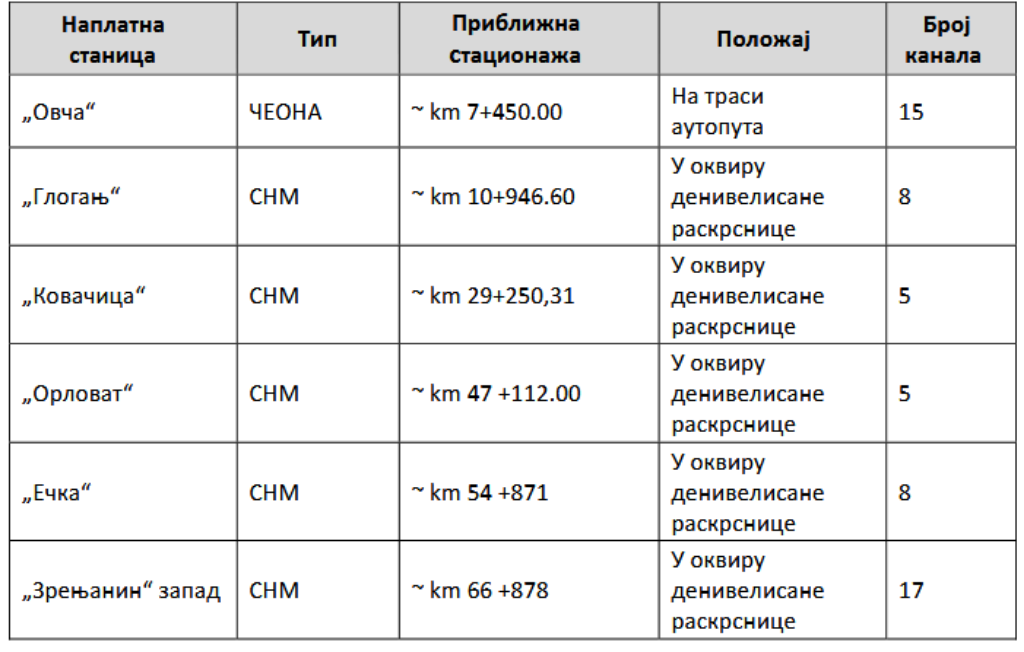

The beginning of the construction of the Belgrade-Zrenjanin highway was initially announced for February 20, 2022.
Take a look at our info-map Construction of Highways and Fast Roads in Serbia and the Region.
B. P.
Companies:
 JP Putevi Srbije Beograd
 Koridori Srbije d.o.o. Beograd
 Ministarstvo zaštite životne sredine Republike Srbije
 Ministarstvo građevinarstva, saobraćaja i infrastrukture Republike Srbije
 AG-UNS arhitektonsko građevinski Institut d.o.o. Novi Sad
 Linglong International Europe d.o.o. Zrenjanin
 Udruženje zrenjaninskih privrednika Zrepok Zrenjanin
Tags:
Corridors of Serbia
Roads of Serbia
Ministry of Environmental Protection
Ministry of Construction Transport and Infrastructure
AG Institut Novi Sad
Linglong
Zrenjaninski poslovni klub
Zrepok
Zrenjanin Business Club
Belgrade Zrenjanin Novi Sad highway
construction of Belgrade Zrenjanin Novi Sad highway
Belgrade Zrenjanin highway section
construction of Belgrade Zrenjanin highway
Vojvodina P
Banat Main Road
Ecka interchange
preliminary design
spatial plan
Comments
Your comment
Most Important News
Full information is available only to commercial users-subscribers and it is necessary to log in.
Follow the news, tenders, grants, legal regulations and reports on our portal.
Registracija na eKapiji vam omogućava pristup potpunim informacijama i dnevnom biltenu
Naš dnevni ekonomski bilten će stizati na vašu mejl adresu krajem svakog radnog dana. Bilteni su personalizovani prema interesovanjima svakog korisnika zasebno,
uz konsultacije sa našim ekspertima.


 Izdanje Srbija
 Serbische Ausgabe
 Izdanje BiH
 Izdanje Crna Gora


 News
News


